Corridors
Water Resources and Equity
Nearly all of San Antonio’s regional centers and urban centers are located along or at the intersection of major transportation corridors. Attractive, multimodal corridors will help connect regional and urban centers to each other. Many will include premium transit service to help manage congestion and bolster safe, convenient and affordable transportation options. But, the corridors must serve more than just a transportation function.
Successfully implementing the SA Tomorrow vision means rethinking those corridors. We need our corridors to provide safe and comfortable access and mobility, serve as attractive gateways and frame compact, walkable mixed-use development. They will also be targeted for higher-density housing and more employment opportunities. A multi-objective and multi-layered approach to corridor improvements can help ensure they are safe, comfortable and attractive for future residents, employees and nearby existing residents.
VIA's Vision 2040 comprehensive transit plan calls for five priority Primo bus corridors to expand on the existing Primo bus route on Fredericksburg Road; the existing Primo route on Fredericksburg Road is planned for Primo Plus or LRT service.
MULTIMODAL CORRIDORS AND COMPLETE STREETS
Many of the community’s major transportation connections are auto-oriented and difficult for pedestrians and cyclists to navigate. Our transportation corridors should serve multiple modes of transportation and better balance the needs of pedestrians, cyclists, transit patrons, motorists and freight vehicles. Allowing a certain mode of transportation or even providing a dedicated facility for pedestrians or cyclists may not be sufficient. The quality and condition of pedestrian, bicycle and transit infrastructure contributes greatly to the attractiveness, safety and use of these facilities. For example, a narrow sidewalk with no buffer between pedestrians and speeding traffic, no landscaping and no furnishings will be less attractive, safe and used than a wider sidewalk with attractive lighting, benches and a wide planted buffer with large street trees.
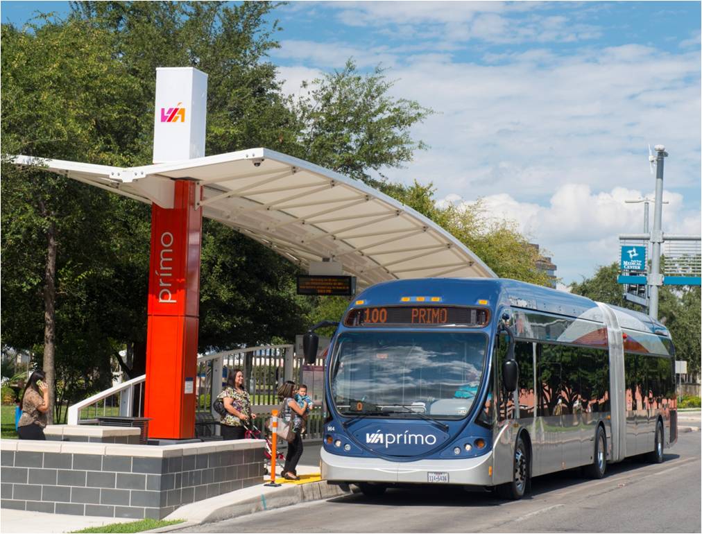
VIA PREMIUM TRANSIT CORRIDORS
VIA’s Vision 2040 Plan identified several corridors for premium transit service. VIA selected the corridors based on existing and potential concentrations of transit users and for their ability to connect two or more regional centers. The premium transit corridors are organized into three types of premium transit service: Priority Primo Bus Corridors, Primo Plus and Light Rail Corridors, and Express Routes.
A modern and diverse transit system includes a variety of modes, speeds, and frequencies and typically includes some combination of traditional bus, bus rapid transit, express bus, and light rail transit.
Water Resources and Equity
Priority Primo Bus Corridors
Priority Primo Bus Corridors provide high frequency transit service with a premium transit vehicle in a shared roadway configuration. The following corridors have been identified as priorities for Priority Primo bus service:
- Looper Premium – Connects the airport, Brooks City Base, South Park Mall and Lackland Air Force Base;
- Randolph – Connects the Central Business District, AT&T Center and Randolph Air Force Base;
- Huebner-Grissom – Connects the Medical Center, Leon Valley and Alamo Ranch;
- General McMullen – Connects South Park Mall and the Medical Center; and
- Bandera – Connects the Central Business District to Leon Valley.
Primo Plus and Light Rail Transit
Primo Plus and Light Rail Transit will provide high frequency transit service with a premium transit vehicle in a dedicated guideway configuration. Primo Plus service will be rubber tire bus service and light rail transit (LRT), utilizing a dedicated rail alignment. The following corridors have been identified as priorities for Primo Plus bus service and LRT service:
- Zarzamora – connects the Medical Center, Crossroads Mall, South Park Mall and Texas A&M University-San Antonio;
- Commerce/Houston – connects the AT&T Center, the Central Business District and Lackland Air Force Base;
- Fredericksburg – connects the Central Business District, Crossroads and UTSA;
- San Pedro – connects the Central Business District, the airport, Blanco and Stone Oak;
- Austin Highway/ Broadway/Perrin Beitel/Nacogdoches – connects the Central Business District, Pearl, University of the Incarnate Word and Rolling Oaks;
- New Braunfels Avenue – connects the Central Business District, Pearl and Brooks City Base; and
- Rockport Sub – connects the Central Business District and Brooks City Base.
Express Routes
The Priority Primo, Primo Plus and LRT corridors will be supplemented by express bus routes utilizing freeways and connecting many of the regional centers. Eleven express routes will have limited stops, 15-30 minute headways between buses and function in mixed traffic.
Water Resources and Equity
Click on the hotspots for information.